The Uig Landscape
From West Over Sea by DDC Pochin Mould, 1953.
To go to Uig is to go to a different country from the rest of the Lews, to go from the moors into the mountains, to the great massif which, with the Forest of Harris, builds the highest ground in the Outer Hebrides.
It is only 32 miles from Stornoway to Uig, but the single-track road, which is untarred beyond the turn to Bernera, makes the way seem much further. It turns off at Garynahine on the Callernish road and twists over moorland county, with Loch Roag on one hand and the outposts of the Uig mountains on the other.
Great Bernera Island in Loch Roag is reached by a branch road and a ferry, across which it is hoped to build a bridge. The sea loch has a long and narrow branch called Little Loch Roag, which runs deep into the hills, its mouth so narrow that, but for the seaweed on its rocks, you would take it for an inland lake as you come down the hill to Morsgail.
Further on are little villages of black houses and fat caterpillars of lazy beds winding down from the townships to the sea loch shore. Still further on, the road enters Glen Valtos, a straight, narrow ravine whose screes nearly meet across the glen. At the deepest part of the rift the floor of the glen is only 400 yards across and the cliffs on either side rise 250 feet.
At the Loch Roag end of Glen Valtos a road branches off for Valtos itself, a village beside some fine sandy beaches. On the dunes at the head of one of these beaches, Berie sands, were found a skeleton, brass ornaments, the remains of an iron knife, a socketed spearhead and an amber bead. Some of the ornaments had probably been made in Norway or Sweden, and the find seems to have been the grave of a Northman of the ninth century.
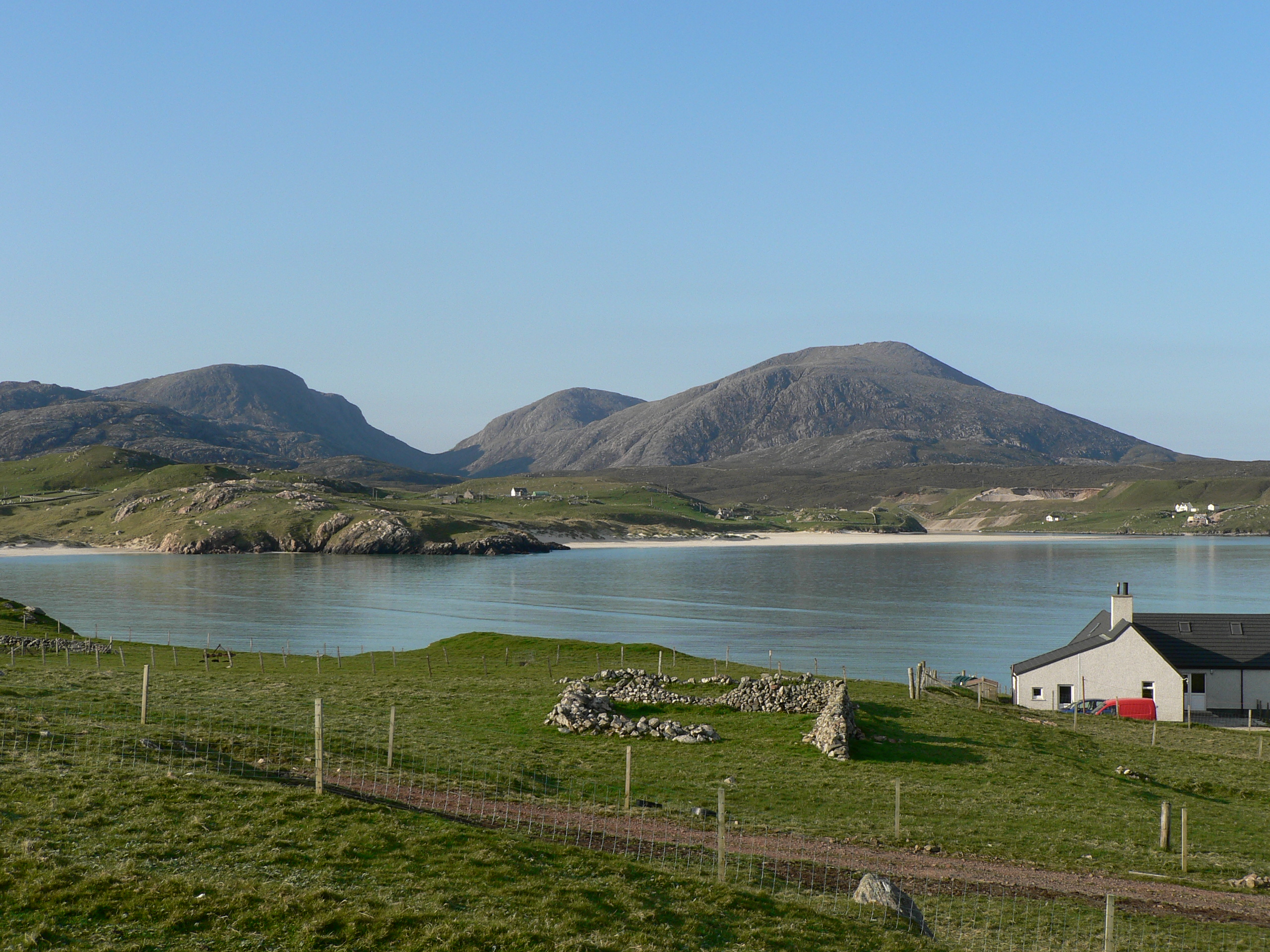
The Amhuinn a’Ghlinne (stream of the glen) which flows down Glen Valtos to Loch Roag is a small thing, and as you follow it past the young plantations of the Forestry Commission and come out beyond its head at Uig, you see that it could not have made the glen for itself. Valtos Glen, in fact, was cut by water dammed up in a loch where Uig Bay is now. At the end of the Ice Age the boulder clay – the material grubbed up by the moving ice – was left, forming a barrier across the mouth of the bay. Lake terraces – old shore lines high up at Carnish across the bay – indicated that this old lake of Uig was at least 175 feet deep. The water escaped on the Glen Valtos line, trenching that great cutting in the rocks, until the sea broke through the boulder clay dam and Uig Bay came into being.
It is a splendid bay. The green dunes surround it, the clear blue sea runs far out, leaving a great field of white sand, and behind, inland, rise the Uig mountains. They are bare, rocky hills, moulded in smooth curves by the ice and rising to Mealisval, 1885 feet, the highest mountain in Lewis. There too, a silver flash under the grey rocks of the hills, is Loch Suainaval, a long narrow lake and the deepest in the Lews. Its depth exceeds 200 feet, and it has an average of 108 feet, as against the maximum of the moorland lochs to the north – 35 feet.
At Uig the road divides. One way goes northward to Gallan Head, three miles away, the site of an ancient church, Tigh a Bheannaich (the Blessing House), on the windswept cliffs. Southward, the road fades out some ten miles further on, at Mealista, where a sheep fank stands on the site of Tigh nan Cailleachan Dubha. The ‘house of the black women’ was a Dominican nunnery and is associated in Uig tradition with fear and black magic and sorcery.