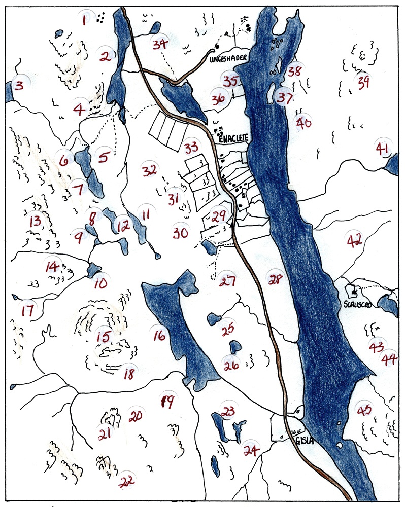
Placenames: Enaclete and Gisla

Place names in Enaclete and the surrounding area, mapped by Finlay and Kenny Maciver. They did Geshader too and you may like to compare the Ordnance Survey map.
| 1. Airigh Dhubh | 23. Caol Loch |
| 2. Loch Croistean | 24. Druim Mor |
| 3. Loch a’ Phealair Beag | 25. Loch nan Learg a Tuath |
| 4. Old Sheilings | 26. Cnoc a’ Charnain |
| 5. Tom nan Laogh | 27. Druim na Cloiche Moire |
| 6. Loch na Craobhaig | 28. Giarol |
| 7. Loch na Craobhaige Moire | 29. Druim a’ Charnain |
| 8. Loch Mor Ruadh | 30. Druim Cul a’ Gharaidh |
| 9. Dubh Loch | 31. Cleite Ban |
| 10. Loch Airigh an Uisge | 32. Tim Leathach Slighe |
| 11. Loch an Eilein choinnich | 33. Beinn Enaclete |
| 12. Druim Coirgavat | 34. Tom Airigh a’ Fhraoich |
| 13. Sidean Corrach | 35. Sidhean Dubh |
| 14. Airigh an Uisge | 36. Beinn a’ Chnoit |
| 15. Cleite Ghiosla | 37. Eilean Dubh |
| 16. Loch Crogavat | 38. Eileanan Glasa |
| 17. Airigh na Ceannamhoir | 39. Creag Ghorm |
| 18. Garry Cleit Ghiosla | 40. Aonaig Mhor |
| 19. Liana Cleite an Fhuarain | 41. Loch Dubh na Creige Guirme |
| 20. Airigh nan Dromannan Leathainn | 42. Cnoc Aonghais |
| 21. Cleit an Fhuarain | 43. Cnoc an Eoin |
| 22. Creagan an Fhigheadair | 44. Druim a’ Loch Rhuaidh |
| 45. Liana Tuath |
