The Island of Lewis in 1857
A Description of the Island of Lewis, from Encyclopaedia Britannica, 8th Edition (1857) ¹
Lewis, the northern portion of the Outer Hebrides, lying off the W. coast of Scotland, from which it is separated by the Minch, a sea about 30 miles across. The name Lewis (Celtic², Leodhus) is probably derived from Leod or Leodus, son of Thorfin, the last Orcadian viceroy that swayed the Norwegian viceregency of this island. Leodus allocated Lewis to his eldest son Torquil, and Harris to his younger son Norman. These were the first McLeods, and the ancestors of the Siol Torquil and Siol Tormaid, who so long held these respective properties. Harris, the southern portion of this island, is much the smaller of the two, and is appended to Inverness-shire, whereas Lewis forms part of Ross-shire.
The boundary line between the two divisions extends from Loch Resort on the W. to Loch Seaforth on the E., where the island is only about 6 miles in breadth. Lewis is triangular in form, having its base towards Harris, while its apex extends northward, and terminates in the Butt. It is 45 miles in length, by 15 in average, and 30 in extreme breadth; between N.Lat 58. and 58.33., and W.Long 6.10 and 7.10. Area, 417,460 acres. The coast is deeply indented by branching arms of the sea, many of which are very capacious, and afford secure anchorage. On various parts of the coast and in these estuaries are numerous small islands which yield excellent pasturage. The chief promontories of Lewis are the Butt, Tiompan, Chicken, Kebuck, and Gallan Heads – all bold and precipitous cliffs rising abruptly from the sea to a great height.
Landscape and Geology
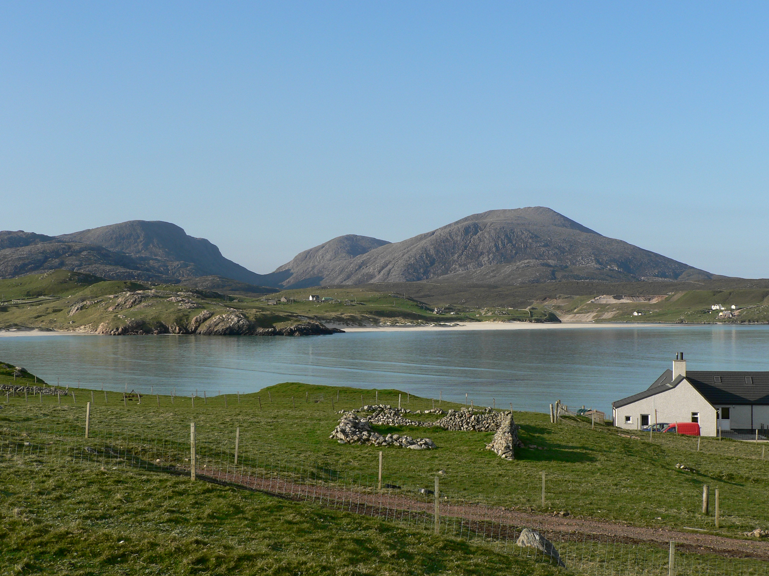
Lewis and Harris are distinct not only in name, but also in their general features. The latter consists mainly of an irregular group of comparatively lofty mountains, some of them rising to the height of 3000 feet, rugged and precipitous on their eastern sides, but generally verdant on their western declivities. That portion of Lewis bordering upon Harris partakes of the same mountainous character, attaining a height of 1400 feet in the Peak of Swainebhal and 900 in in the Hill of Roineval. Alluvial straths of fine pasturage, and vales of romantic beauty, interrupt and variegate this hill district, which may be regarded as terminating at a line extending from the head of Loch Roag on the W. to that of Loch Shell on the E. Northward from this line Lewis presents a somewhat monotonous undulating expanse of table-land, interrupted only by a few elevations, the loftiest of which, Monach, does not exceed 810 feet.
Throughout the interior, hill and dale are alike clothed by vast accumulations of peat-moss, varying from 2 to 18 feet in depth – studded with numerous lakes, and intersected by silent streams and quiet rivulets. This dark-grounded interior is bordered all along the sea-coast by a fringe of arable land, varying in breadth from half a mile to 3 miles, and dotted over with populous villages. The arable soil consists generally of decomposed moss, varying in quality and fertility according as it is intermixed with and based upon siliceous or shelly sand, alluvial till, gravelly loan, or marly clay. The fundamental substratum of Lewis consists of gneiss. On the W. shore it is traversed by veins of granite, and turbance. Near the Butt there are rock masses of orange-red feldspar containing laminar scales of argillaceous schist, and beds of green compact feldspar. Partial deposits of limestone occur at several places of the N.E. coast. Quantities of bog-iron ore protrude in many places, and its prevalence is indicated by the ferruginous impregnation of numerous chalybeate springs. In Harris, Dr MacCulloch found those rather rare minerals, Sahlite, and dark green Cocolite, in serpentine embedded in limestone.
Climate and Wildlife
The climate of Lewis is mild and equable, and its humidity is much under the average of that of Scotland. From its flatness and the absence of high hills, it often escapes the contents of condensed clouds; and the entire surface is exposed to the action of the dry NE winds which prevail in spring, and often till midsummer, when the moors are thoroughly exsiccated. The great mildness of the climate, however is no doubt chiefly due to the influence of the gulf stream. The temperature, even in the interior, rarely continues long at the freezing point, and snowfalls are of very brief duration. Observations taken for nearly four years at Stornoway, in N.Lat 58.12, ive the mean annual temperature of the –
Year: 46 5′
Winter: 40 8′
Spring: 40 5′
Summer: 51 1′
Autumn: 51 6′
Average annual fall of rain: 30.2 inches
The extremes of temperature rarely extend over more than 30 degrees from 35 to 65. The animal kingdom in Lewis is especially rich in the ornithological department. The swan, grey goose, rain-goose [red-throated diver], eider-duck, teal, widgeon, heron, snipe, woodcock, red grouse and ptarmigan are among the most important. Otters and seals abound on the rivers and shores; and deer and hares are common.
Archaeology
The most remarkable ancient remains are the so-call Druidical standing stones, or Temple of Callanish, perhaps the most perfect in Britain. The are 43 in number, arranged in a cruciform manner, with a circle at the intersection. The long leg of the cross extends north and south 600 feet, and the transverse line at right angles measures 200 feet. Both measurements include the circle, which is 63 feet in diameter, consisting of 12 stones, ranging from 7 to 9 feet in height, with a central obelisk 15 feet high.
The north extremity of the long leg of the crucifix is formed into an avenue by two parallel lines of 16 obelisks, generally from 5 to 6 feet in height, the loftiest being 13 feet. They all rest on a casewayed base, in which they are firmly impacted by small stones. On a lower eminence, half a mile from the Callanish Temple, there is another cluster of standing stones disposed into two concentric circles. They are nearly uniform in height, but are deeply embedded in growing moss. In its vicinity there is another irregular semicircular group of erect stones; and throughout the country there are various specimens, single and in pairs, of those standing obelisks, probably erected as tombstones or cenotaphs, commemorative of the downfall or achievements of noted warriors.
Rounded conical tumuli and monumental cairns are abundant. Belonging to a later age are many remains of circular duns or round towers, the most perfect of which are those of Bragar and Carloway. The latter was originally upwards of 30 feet high, constructed of unhewn stones, with a double dry wall, containing spiral passages, from which the besieged could aim their arrows at assailants.
It is very broad at the base, gradually narrowing and tapering towards the summit. We find also here, particularly on the west coast and towards the Butt extremity, numerous small chapels and religious cells, generally insignificant in size, but strongly built of stone, cemented by a shelly mortar, which still retains its hardness and tenacity. The most perfect in design and architectural integrity is M’Leod’s Chapel at Oreby [Europie], dedicated to Saint Molonah [Moluah] and which was till recently much frequented by incurables for the healing virtues believed to be inherent in its consecrated precincts.
Improvements
Since Lewis came into the hands of the present proprietor, Sir James Matheson, in 1844, large sums have been expended in carrying out improvements on the estate, as well as ameliorating the physical, social and intellectual condition of the people. In the short space of seven years, the sums so spent equalled the purchase price of the property, £190,000. The erection and endowment of educational institutions; the introduction of improved modes of cultivations, and improved breeds of horses, sheep and cattle; and the institution of cattle and horticultural shows, are among the means that have been adopted.
Besides improving and repairing 80 miles of roads formerly constructed, the present proprietor has formed about 100 miles of new roads, with several bridges. The great proportion of the arable land is in the hands of small crofters holding allotments varying in extent from 3 to 8 acres; and to show how much the inhabitants are dependent for food on external supplies, it may be mentioned, that in the seven months from 1st January to 31st July 1855, no less than 18,932 bolls of meal, costing about £20,825, were imported, and that in consequence of only a partial failure of the potato crop of 1854. The total failure of the potato crop of 1846 entailed an outlay (borne, in the first instance, solely by the proprietor) of £29,079 for meal alone.
To obviate, in some measure, the evils arising from over-population, the proprietor has from time to time furnished free means of transit to other parts to such as were willing to accept of them; and accordingly, in 1851-52 and 1855, about 1800 souls left the island for various parts of Upper and Lower Canada. An opportunity of free transit is now annually provided.
Great efforts are being made to introduce scientific modes of cultivation; and, with that view, about 2000 acres of previously untilled moorland and meadow pasture have been reclaimed, and a great portion of it converted into large model-farms, held by skillful lowland tacksman, who exhibit the practical value of the most improved modes of cultivation. At the cattle shows prizes are annually adjudged to the best specimens of every variety of farm stock and produce.
Parishes
Lewis is divided into four parishes, each having its own church, school and manse. Of late years the districts of Cross and Knock have been converted into quod sacra parishes, having 2 churches. There are 8 Free churches, 5 of which have settled pastors, while the other 3 are supplied by probationers; and there are several Free Church schools in each parish, — the whole island numbering 38, showing an annual attendance of 2505 pupils. The few Roman Catholics on the island receive periodical visits from an ecclesiastic of that persuasion. Here, as in most parts of the Highlands of Scotland, only a small fraction of the people remained with the Established Church at the Disruption. More than 19 20ths of the inhabitants of Lewis belong to the Free Church.
Industry
The fisheries are the most important branches of industry carried on here. In 1855, 294 boats were engaged in the herring fishery at the various stations; 35,227 barrels of herrings were cured, and 4000 taken and consumed uncured, the probably value of which was about £56,840. In that year 903 tons of cod, ling or hake were cured, and 250 tons taken and consumed uncured, the probably value being about £17,043. The number of fishermen and boys employed in manning the boats was 2982; persons employed in gathering bait, baiting lines, as carters, &c., 2900. An improved slip for the launching of boats is no in the course of erection, under the direction of the proprietor and Scottish Fishery Commissioners, at the port of Ness, the great centre of the Lewis deep-sea fishing. The quantity and estimated approximate value of the exports from Lewis in 1855 were as follows:–
Stornoway, the only town of Lewis, and the capital of the Western Hebrides, is situated at the head of a bay on the east side of the island. It is well and regularly built and its streets are lighted with gas. The most prominent of its buildings are the parish church, Free church and Episcopal chapel; several of the schools, jail and the masonic lodge. On an eminence overlooking the town is the magnificent mansion of the proprietor, recently erected in the castellated Tudor style. The castle grounds are extensive, and laid out with great taste.
The industrial female seminary in Stornoway is a neat and commodious building, erected and endowed by the proprietor and his lady in 1847, at a cost of more than £2000. It is attended by about 150 girls of the poorer classes, who are instructed in Ayrshire flowering needlework, domestic millinery, and laundry-work, as well as the elementary branches of education. The masonic lodge contains elegant assembly rooms, reading rooms, and a public library. Stornoway has a branch office of the National Bank of Scotland, customs-house, a savings-bank, Sailor’s Home Hospital, and gas and water works.
There are also commodious piers, and a building-dock, with a Morton’s patent slip worked by steam, and fitted to haul up ships of 800 tons burden. The entrance to the harbour is marked by a lighthouse and beacon. Near Stornoway there is an extensive tilery for manufacturing bricks and tiles, erected at considerable expense by the proprietor. He has also introduced the tussac grass pertaining to the Falkland Islands, which appears to thrive remarkably well in the vicinity of the Castle of Stornoway. On 31st December 1855, the number and tonnage of vessels registered as belonging to the port were:
Not above 50 tons: burden 38, tonnage 989
Above 50 tons:burden 12, tonnage 1245.
During that year the number and tonnage of vessels that entered and left the port were:
Coastwise, sailing vessels: inwards 98, tonnage 4564; outwards 38, tonnage 1418
Coastwise, steam vessels: inwards 85, tonnage 16,961; outwards 87, tonnage 17,102
Colonial trade, sailing vessels: inwards 2, tonnage 63
Foreign trade, sailing vessels: inwards 13, tonnage 832; outwards 42, tonnage 2119.
Pop. of Stornoway (1841) 1354; (1851) 2440.
Pop. of Lewis (1755) 6386; (1831) 14,541; (1841) 17,037; (1851) 19,711.
Notes:
1. This article from EB was also published in a single slim volume in 1857.
2. The Stornoway Library copy of the slim volume, ex libris Dr D Macdonald Gisla (Dolly Doctor), has a margin note in (his?) pencil, replacing ‘Celtic’ with ‘Norse’. He also highlights the passage about emigration.
If you would to leave a comment or get in touch with us…
You can visit our facebook page Uig Historical Society where we will be able to contact you. We have a great facebook family who are always happy to help with anything from dates, photographs and any information regarding Uig.